
Achikochi: Feng Shui Compass
Masayuki Suda
Direction lines on a real map
The app overlays direction lines on a real map. Users can set a reference point and see compass sectors radiating from it.

Track train passengers and their data.
The app tracks train passengers, providing data on speed, altitude, coordinates, and direction. Users can locate themselves on a map and access information with a single click.
Showing 501–520 of 1,000 ranked alternatives.
Masayuki Suda
Direction lines on a real map
The app overlays direction lines on a real map. Users can set a reference point and see compass sectors radiating from it.


David Southgate
And view coordinates in real time
Displays current location and altitude. View coordinates in UTM, DMS, MGRS, and others. Access location within the , Apple Watch , or as a complication.

Klaus Neuendorf
Track routes and analyze speed data
Record driving routes with GPS tracking. View speed, distance, duration, and average speed. Analyze maximum speed, acceleration times, altitude changes, and stops. Display data in charts for performance review.

Aviation.Direct (Pty) Ltd
Aviation navigation for Southern Africa.
The app provides aviation navigation for Southern Africa with a GPS moving map and detailed airfields database. It includes airspace information, flight planning, and an E6B calculator for enhanced situational awareness.


University of Illinois at Urbana-Champaign
Check in passengers for routes
Lets drivers check in passengers for scheduled routes. View passenger details, confirm pickups, and track route progress in real time. Receive notifications for delays or changes.


Thor Mikashima
Record and relive travel journeys.
The app records user routes with GPS, allowing users to relive journeys using maps, photos, and speed data. Users can view color-coded tracks by speed or elevation and browse photos taken along the route.

Mapway Inc.
Check live UK train times easily.
The app provides live train times, departures, and arrivals for thousands of UK stations. It allows users to track train status and save selected stations for quick access to rail information.

Alexander Abdo
Track train arrivals and departure times
View real-time train schedules sorted by departure time. Tap a train for full station schedules and walking directions. Check Status for delays or service updates. Access the MTA subway map for navigation.

Zipo Apps Ltd.
Track speed with real-time GPS updates
GPS Speedometer tracks real-time speed using GPS. Users can monitor current speed and record maximum speed during activities. The allows selection of units and displays speed data on a map.

Christoffer Sjoeberg
Swedish train schedules and delay information.
The app provides a personalized train schedule for frequent destinations in Sweden. Users can check station arrivals, departures, and traffic information, including delays.
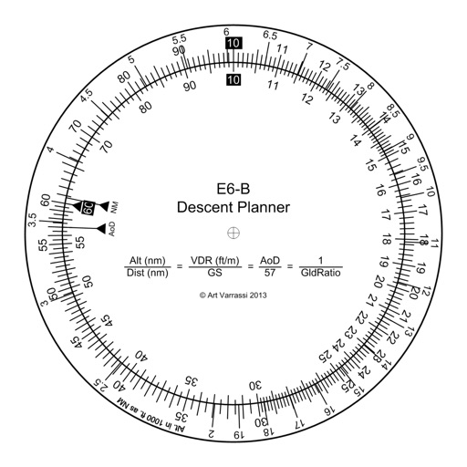
Arthur Varrassi
Circular slide rule for descent planning.
The app offers a functional circular slide rule for descent planning. It calculates top of descent distance, angle, rate, glide ratio, and maximum glide distance.

John Spinks
Locate position on OS maps
GPS OS allows users to determine their location on Ordnance Survey maps of Great Britain and Ireland without needing a phone signal. It provides high-accuracy positioning using OSTN15 transformation data.

Robert Gaddy
Log user finds with GPS coordinates.
The app records user finds, capturing GPS coordinates for precise location noting. Users can add photos, custom categories, and tags to their finds, with options to edit and export data.

Jackson Loeffler
Track train status and alerts
Access real-time train status, alerts, and construction updates. Monitor service disruptions and view the latest timetable with offline access. Use the trip planner for data and special event schedules. Pin trains for quick status checks.

Performance Champions, Inc.
Record GPS data and save notes
LogGPS records GPS data including coordinates, altitude, speed, and accuracy when the save button is pressed. Users can add notes, edit or clear them between saves. Data is stored with timestamps and can be reviewed later.

永刚 陈
Speed, odometer, and altitude with GPS
Trips with modes for walking, , and biking. View speed, distance, and elevation via GPS. Use HUD mode to display speed on the windshield. Monitor odometer and altimeter readings. Export trip data and set distance alerts.

Apps are ranked by functional similarity, category fit, rating confidence, and popularity.