Learn and practice IFR procedures with realistic simulations. Navigate using charts and instruments. Practice approaches, holds, and instrument approaches. Track progress and review performance metrics.
Calculate parameters such as time, distance, and fuel consumption. Adjust wind direction and speed for accurate wind correction. Use the E6B calculator for fuel planning and navigation. Visualize and manipulate dials and scales for precise planning.
Access real-time METAR, TAF, and NOTAM data for global airports. Plan and save flight routes with offline storage. Sync data via iCloud. View briefings and pilot reports. Track conditions and flight-related alerts.
Convert units between 30,000+ conversions. Switch between 160+ currencies including cryptocurrencies with live rates. Save favorite conversions for quick access. Display results in fractions when applicable.
Track aircraft positions in real-time using ADS-B data. View live paths, altitudes, and speeds. Search for specific planes by identifier. Receive alerts for nearby flights and airspace changes.
Play combat flight simulations with modern and WWII aircraft. Explore detailed environments and infrastructure. Engage in dogfights, bombing missions, or ground target missions. Customize aircraft and manage in-game inventory.
Access aviation and navigation data for flight simulation. View Jeppesen and IFR coverage at airports worldwide. Download and manage for use in simulated flights. Sync with flight simulation software for real-time data.
Provide accurate GPS coordinates and altitude readings. Display direction and map integration. Enable location-based reminders and track movement routes. Adjust settings for different navigation modes.
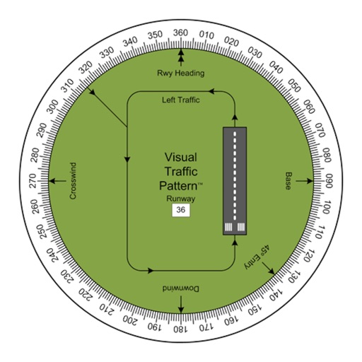
Allows pilots to view runway patterns with finger rotation. Display includes left and right patterns, crosswind, downwind, base, and 45-degree entry headings. Magnetic runway orientation matches aircraft heading for approach visualization.
Track flights in real time with live air traffic data. View aircraft positions on global maps. Identify planes by pointing device at them. Monitor flights of contacts or follow global aircraft movements. Set alerts for specific flights or locations.