The app records strike and dip measurements, bearings, and plunge. It simultaneously displays the user's latitude, longitude, and elevation, and saves measurements with photos and notes.
by Hunt Mountain Software★ 5.02 ratingsNavigation$4.99Data updated 2026-10-08
Provides real-time , atmospheric pressure, latitude, and longitude data. Users can switch between GPS and device altimeter for readings. Camera integration allows photo capture with location data overlay.
Calculate precise celestial positions using real-time data from 1900 to 2050. Input date and time to instantly recalculate GHA and declination for the Sun and Aries.
Track location with live coordinates and altitude. Convert GPS data to readable addresses. Monitor speed and heading for motion tracking. Access real-time environmental data for navigation.
Scan documents, receipts, and notes using OCR to extract text. Save scans as PDF or JPEG. Share files directly or export text for reuse. Organize scanned items into folders. Edit and annotate scanned images.
Track fuel sales and manage inventory with real-time meter readings and stock comparisons. Record lubricant and credit transactions. Generate reports on tank-wise stock and density. Sync data across web and mobile platforms.
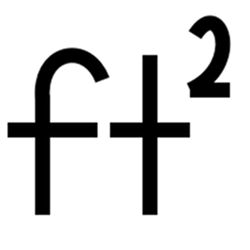
Calculate footage by entering length and width for multiple rectangles. Support measurements in , inches, or both. Export calculations as CSV for further use.
Send location via SMS, WhatsApp, or email with GPS coordinates, altitude, and links to Google Maps and Apple Maps. Include actual address in emails. Share real-time position with contacts or emergency services.
Measure and map 3D terrain with X, Y, and Z coordinates. Save, email, or upload data to CAD. Calculate slope percentages and elevation above sea level. Include photos with location data and use built-in compass for accurate orientation.
The app calculates sunrise and sunset times for any location and date. It displays the earliest and latest sunrise and sunset times for any latitude, along with the equation of time and sun inclination.
Performs X, Y, R radius calculations and theta measurements. It includes -specific functions for ducting offsets and angle computations. Features dimensional math, geometry, and trigonometry tools for precise construction calculations.