The app offers integrated navigation tools including a full-screen map, GPS, compass, altitude, UTM, and magnetic declination. It displays current altitude, speed, and UTM coordinates with precision grids for various measurements.
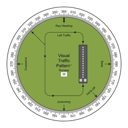
Allows pilots to view runway patterns with finger rotation. Display includes left and right patterns, crosswind, downwind, base, and 45-degree entry headings. Magnetic runway orientation matches aircraft heading for approach visualization.
Track boat movement with a showing direction. View current in knots, miles, or kilometers. Set limits and switch units. Display a map of your cruise route and share it. Log maximum and average .
View high-definition 3D globe and latest satellite imagery. Load map tile data for detailed terrain and urban features. Use oriental compass for direction. Access historical street view for past locations. Measure area and distance on .
Display the direction and distance to the Kaaba using a interface. Tap the Adhan button to trigger a sound. Adjust device orientation to align the Kaaba indicator for navigation.
Navigate using precise latitude and longitude coordinates. View real-time sunset and sunrise times. Use integrated flashlight to illuminate paths. Track location for outdoor activities.
Measure distances and angles using a rangefinder and inclinometer. View GPS coordinates and map overlays. Take geo-tagged photos and videos. Use a compass and navigation calculator for orientation and route planning.
Camera measurement maps waypoints compass planning
The app turns an iPhone or iPad into a field toolkit for camera measurement, maps, waypoints, compass work, and astronomical planning. It estimates distance, inspects angles, saves waypoints, measures map shapes, and plans around sunlight.
The app plots the location of the Kodesh Hakodashim and uses the user's location and digital compass to point towards it. The word "Mizrach" lights up when users are in the vicinity of the correct direction.
Navigate waterways with detailed charts, build routes, and record tracks. View tides and currents. Set waypoints and track progress. Share maps and access free US charts for safe boating.
Determine UTM references, hemisphere, and WGS84 coordinates. Display device accuracy readings. Share location via Twitter. Includes USA UTM zone guide.