Plan flights, track performance, access real-time data
Plan flights with real-time performance data and predictive analytics. Input aircraft details to calculate fuel consumption and optimal routes. Access weather information and regulatory data.
by Aircraft Performance Group, LLC★ 5.02 ratingsNavigationFreeData updated 2026-09-06
Track flights, view aircraft, and monitor destinations
Track real-time flight data for AIRLINES, including destinations, aircraft models, and flight speeds. View flight paths and radar maps. Receive notifications about departures and arrivals. Explore aircraft details and pilot perspectives.
Track direction with a that adjusts based on your orientation. View local weather forecasts without requiring an account. Access weather widgets on your home screen. Monitor the KP index for geomagnetic activity.
Access aeronautical data and flight publications for navigation. View Digital Aeronautical Flight Information File (DAFIF) and flight charts. Retrieve weather information and navigation aids. Manage flight plans and check aircraft status.
Navigation provides flight planning and in-flight calculations. Users can customize quick access buttons, configure units, and manage blocks and airtime.
View route maps to find options globally. Search for routes and transfer points. Check travel times, stops, and traffic conditions. Get real-time updates on schedules and delays. Navigate public transportation with detailed maps and directions.
View turbulence reports and overlays on Apple Maps. Access hundreds of aviation and weather maps. Filter turbulence data by time and altitude. Share turbulence maps with others. Retrieve detailed turbulence information with a tap.
View and analyze GPX and KML files to explore existing tracks or plan new routes. Display detailed maps with waypoints, paths, and elevation data. Share tracks via email or social media. Sync with GPS devices for real-time navigation.
Track location, speed, altitude, and heading using built-in GPS. Customize with widgets for quick access. View real-time movement data and adjust settings for navigation.
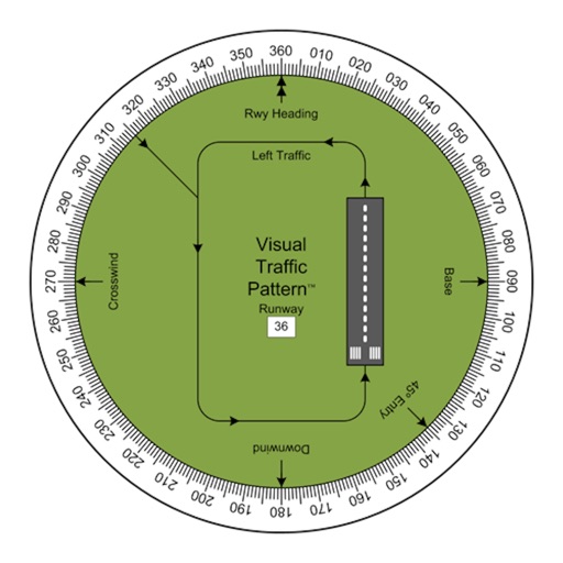
Allows pilots to view runway patterns with finger rotation. Display includes left and right patterns, crosswind, downwind, base, and 45-degree entry headings. Magnetic runway orientation matches aircraft heading for approach visualization.
Track wildfires in real time with maps showing current fire locations and spread. Receive alerts from verified sources including current and former firefighters. View detailed reports and updates from first responders and reporters.