

Apps Like Pressure Altimeter Tracker for iPhone and iPad
Pressure Altimeter Tracker screenshots
Ranked alternatives
Showing 101–120 of 1,000 ranked alternatives.

Live Sky
Dapperfinch Inc.
Look up celestial coordinates in real time
View coordinates for celestial bodies including planets, the Moon, the Sun, stars, and deep sky objects. Check if objects are above the horizon with a green icon. Click to access detailed information.


Garmin Pilot
Digital Cyclone
Track weather and plan flights
Plan flights with detailed route mapping, weather data, and fuel calculations. Access real-time weather briefings and interactive charts. Log flight details and manage preflight checklists. Sync with avionics for consistent navigation.

iDevice Monitor
Artem Tselikov
Device hardware performance and sensor data.
The app displays technical data about the device's hardware, performance, and environmental sensors. It offers real-time metrics for CPU, RAM, storage, network, and various device sensors.


WGPS 2 AR | GPS Display App
Makoto Katsumata
Locate, share, and update position
Displays current location with address, latitude, longitude, altitude, and time. Includes AR navigation and satellite map views. Share location data. Choose from 4 theme colors. Automatically updates location and unlocks screen.



Map Coordinate
Xuan Luong Do
Find coordinates and get directions
Coordinates can be viewed and shared via decimal degrees, degrees-minute-seconds, degrees-minute-decimal, UTM, and military grid systems. Users can tap a map to retrieve coordinates and directions.

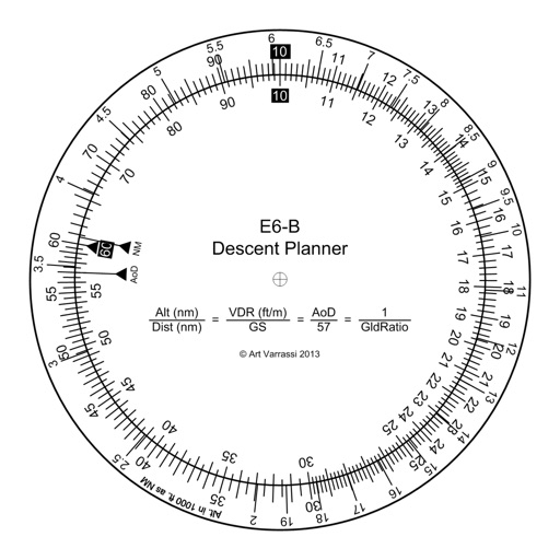
E6B Descent Planner
Arthur Varrassi
Circular slide rule for descent planning.
The app offers a functional circular slide rule for descent planning. It calculates top of descent distance, angle, rate, glide ratio, and maximum glide distance.

PFMA E6B
Gonzalo Esteban Astica Capra
Manage flight data and calculate fuel burn
Navigation provides flight planning and in-flight calculations. Users can customize quick access buttons, configure units, and manage blocks and airtime.

Altimeter Offline
Arnau Egea
Offline altimeter for outdoor activities.
The app displays geographic coordinates and current elevation. It records the highest altitude reached and shows altitude in meters and feet.



Transparent Elevation
ASS Ltd.
See altitude with chosen background.
The app displays current altitude and saves it with a chosen background image. Users can share these images instantly on social media platforms.

How we rank alternatives
Apps are ranked by functional similarity, category fit, rating confidence, and popularity.