The app provides aviation navigation for Southern Africa with a GPS moving map and detailed airfields database. It includes airspace information, flight planning, and an E6B calculator for enhanced situational awareness.
by Aviation.Direct (Pty) Ltd★ 5.05 ratingsNavigationFreeData updated 2026-10-01
Track real-time Green Line train locations and arrival times. Find the nearest station and view next train arrival minutes. Use an interactive map to see train movements. Share your location with friends.
View real-time traffic conditions and incidents across . Access live camera feeds from 1,297 locations. Use the today screen widget to see nearby traffic updates. Navigate maps with current incident markers. Optimize for all iPhone and iPad models.
Locate and navigate to graves of Tzadikim and Rabbanim in real time. Choose between miles or kilometers. View locations of over a thousand graves across Israel, Europe, Morocco, North Africa, and the Middle East. Search by country or region.
NAVITER - Informacijske tehnologije in druge storitve, d.o.o
Record flights and track your path
Record flight data using Bluetooth-connected instruments. Display live weather and traffic information. Provide guidance for safe landing approaches. Sync with external flight devices for real-time data sharing.
Track and save GPS locations for cars, hotels, and other places. View maps in Roadmap, Satellite, Hybrid, and Terrain modes. Share locations quickly and search for points of interest with GPS navigation.
Track , paragliders, planes, and helicopters in real time with live position and flight path data. View airfield details including frequencies, runways, and METAR reports. Access rain radar, cloud layers, and flight time calculations.
Set feeding distances and durations for the feeder. Activate feeding via Bluetooth connection. Monitor feeder status and receive notifications when feeding starts or stops. Adjust settings remotely through the .
Navigate using distance and direction without a map. Set destinations and receive step-by-step guidance. Track progress and view distance metrics. Works independently on Apple Watch with GPS.
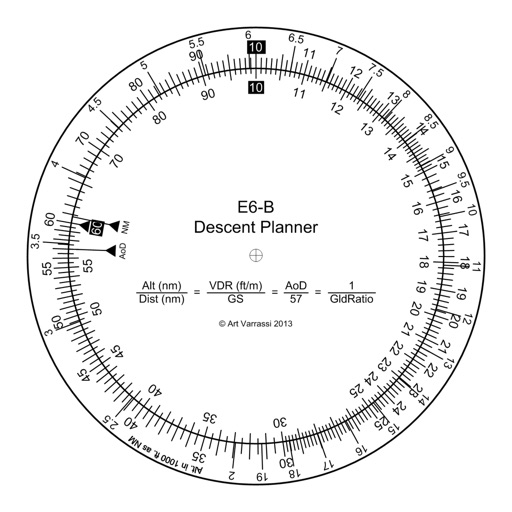
The app offers a functional circular slide rule for descent planning. It calculates top of descent distance, angle, rate, glide ratio, and maximum glide distance.
Track real-time paths and locations using 3D maps. View aircraft details, identify drones, and monitor airport activity. Set alerts for specific flights or locations. Share data with others.
Set landmarks on iPhone. View them on Apple Watch mini-map or iPhone AR overlay. Navigate with real-time directions. Receive turn-by-turn guidance. Sync location data across devices. Share map views with others.
View real-time METAR and TAF data for airports, sea plane bases, and heliports. Search by name, ICAO, or IATA code. Display nearest, all, or favorite locations on an interactive map. Add or remove favorites. Track weather conditions and forecasts.