Displays altitude, coordinates, and speed with options for metric or imperial units. Shows accuracy and warns about signal issues. Offers aircraft mode with in feet. Compares current altitude with known values. No ads or data collection.
Detects objects by measuring magnetic field strength. Displays real-time magnetic field levels in microtesla. Alerts users when is detected nearby. Uses built-in phone sensors for accurate readings.
Navigate with a precise and responsive that works without internet or GPS. View a simple, easy-to-read dial for direction. Ideal for hiking and outdoor exploration.
Logs acceleration, gyroscope, and magnetic field data simultaneously. data as CSV. Enable real-time visualization for live data viewing or disable for higher accuracy. Adjust sampling rate based on hardware capabilities.
Monitor Wi-Fi and Bluetooth connections to identify nearby devices. Track network activity and detect unknown devices. Remove suspicious connections to protect personal information. Set alerts for new devices.
Record photos and videos with real-time data overlays. Use augmented reality for navigation. Access proven navigation and image processing technologies. Capture geospatial data during recordings. Share media with embedded location and time stamps.
+ uses the device's magnetometer for real-time detection. It provides smart alerts for different types. Users can adjust sensitivity settings and view detection history. The supports multiple detection modes for various search scenarios.
Detect unauthorized surveillance devices using WiFi and Bluetooth scans. Identify infrared and listening devices. Alert users to potential security threats in their environment.
The app provides real-time pitch and roll data using animated gauges. Users can customize vehicle silhouettes and set tilt warnings with optional audio alarms.
Detect electromagnetic fields using phone compass. Measure magnetic and electric fluctuations. Identify sources of interference. Calibrate for accurate readings. Display real-time field strength. Save and share measurement data.
Calculate output voltage and power after attenuation
Calculate output voltage, power, and attenuation based on input voltage and dB loss. Specify impedance for accurate results. Convert between Watts, dBm, and dB values. Calculate NMR pulses using reference power and pulse length.
Provides real-time device orientation based on magnetic fields. Allows switching between true and magnetic north. Displays compass direction and azimuth. Includes declination information. Offers tilt sensitivity settings.
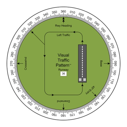
Allows pilots to view runway patterns with finger rotation. Display includes left and right patterns, crosswind, downwind, base, and 45-degree entry headings. Magnetic runway orientation matches aircraft heading for approach visualization.