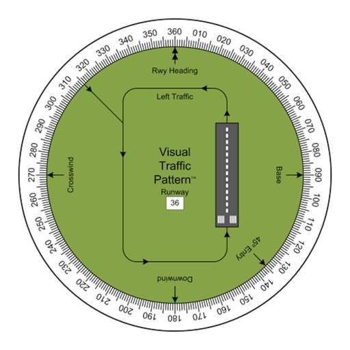
Allows pilots to view runway patterns with finger rotation. Display includes left and right patterns, crosswind, downwind, base, and 45-degree entry headings. Magnetic runway orientation matches aircraft heading for approach visualization.
The app provides digital maps of Austria with hill shading and object names. It includes topographic maps and offers functions like searching by name or coordinates, GPS features, and measuring distances.
The app uses GPS to identify the zip code, address, and GPS coordinates of the current location. It functions in US locations and almost any international geography.
Find prayer using device compass and GPS. Display bearing and compass needle. Set location manually or automatically. Works offline and without internet. No location data is shared. Adjust compass for accurate readings.
Track friends' locations and receive directions to their real-time positions. Locate a lost device by checking the 's website. View friends' whereabouts on a map at any time.
The app offers a virtual 3D journey through a field of stars. Users can navigate by turning and tilting their device and access a control panel with a double-click.
Trips with modes for walking, , and biking. View speed, distance, and elevation via GPS. Use HUD mode to display speed on the windshield. Monitor odometer and altimeter readings. Export trip data and set distance alerts.
The app looks up any latitude/longitude coordinate on the earth's surface and displays it on a satellite image or map. It is useful for finding a location specified only by its coordinates or to map out a SIGWX area.
The app provides a trail guide for the Sunshine Coast of British Columbia, Canada. It includes over 200 named trails with difficulty ratings, lengths, and descriptions.
View GPS coordinates globally with a simple interface. Record and name waypoints during travel. Manage multiple waypoint lists. Import and export data as CSV or KML. Sync waypoints automatically via iCloud.