
iPhone Screenshots





Description
Vulcana shows the living Mediterranean: earthquakes, volcanoes, wind and storms on one live map, and turns them into music.
Made for anyone who lives on, or travels to, the edge of an active volcano: Sicily, the Aeolian islands, Naples, Greece and the whole Mediterranean.
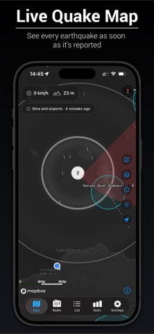
LIVE QUAKE MAP
Every earthquake reported by INGV, EMSC and USGS appears on the map as soon as it is published, coloured by magnitude. For a recent quake, rings show how far it could have been felt. Filter by time, magnitude and distance, or browse them all in a list.
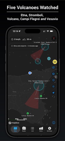
FIVE VOLCANOES, WATCHED
Etna, Stromboli, Vulcano, Campi Flegrei and Vesuvio each have a ring that shows their seismic unrest compared with the past month. For Etna and Stromboli you also see the official aviation colour code issued by INGV, with the observers' own notice: what they see, the ash cloud, and when it was issued.
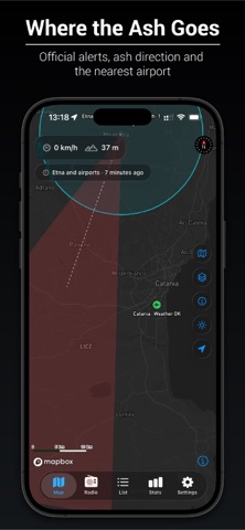
WHERE THE ASH GOES
When the official code is Orange or Red, an ash cone points where the summit wind would carry it, towards Catania, Reggio Calabria or Naples.
AIRPORT WEATHER
Catania, Comiso, Palermo, Trapani, Reggio Calabria and Naples, each coloured by its weather report: thunderstorm, low visibility, volcanic ash. Turn on alerts and your phone tells you when the weather changes at the airport that matters to you.
WIND AND STORMS
Drifting streaks show the wind over the island, and a purple glow marks thunderstorms before they reach you.
RADIO OF SICILY
A piece of music that never repeats, played live by the forces around you. The wind strums an Aeolian harp. The heat wakes the cicadas, the evening wakes the crickets, and they call and answer each other. Birds sing at sunrise. Storms roll in as thunder. The volcano you listen to has its own voice: Etna's deep drone, Stromboli's bursts and sparks, the steam of Vulcano, the slow breath of Campi Flegrei. Climb a mountain and the sea fades as the air thins and a shimmer of bells appears. Drive and the harmony quickens. It keeps playing with the screen off.
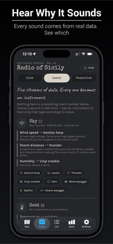
LEARN WHY IT SOUNDS
Every sound comes from real data, and the app shows you which: tap a layer to hear it alone and read what moves it. Or try Scenarios to hear a storm, an eruption or a quiet August night.
GUESS THE MAGNITUDE
Felt a tremor? For an hour Vulcana hides the magnitude of a quake near you. Guess it, see how close you were, build streaks and climb from Novice to Master Seismologist.
SPEED AND ALTITUDE
A speedometer and altimeter on the map and in the radio, with a button that keeps the screen on for a phone in a car holder.
PRIVATE BY DESIGN
No account, no ads, no tracking. Your precise location, speed and altitude never leave your iPhone. Only an area about 11 km across is used to look up the weather.
Please note: Vulcana is not an official warning system. It shows public scientific data as it is published, sometimes minutes late or later revised. For your safety, follow Civil Protection and INGV. Airport colours describe the weather, not whether flights operate.
Data: INGV, EMSC, USGS, MET Norway and NOAA. Maps © Mapbox © OpenStreetMap contributors.
Made by SIA SPACE, an audiovisual studio.