
IGNIS | Wildfire Operations
Overlay maps, access layers, track fire weather
Ignis Technologies, Inc
iPhone Screenshots


iPad Screenshots


Description
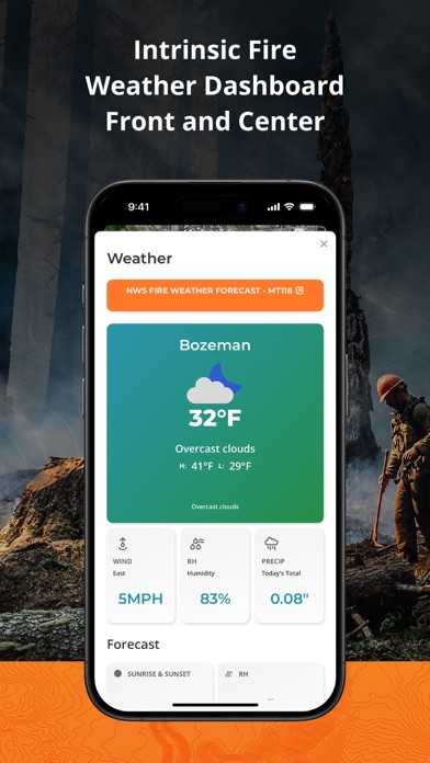
Overlay GeoPDF maps on dynamic base maps. Access curated wildland fire layers. Use the Fire Weather Dashboard for forecasts. View fire-specific symbology and reference documents.
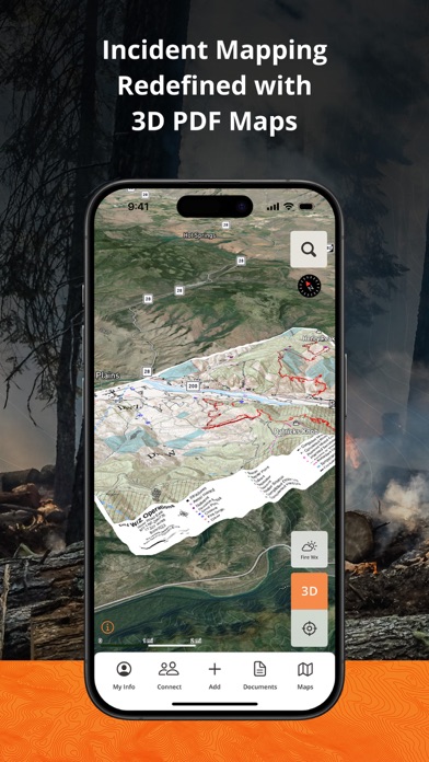
**Fireline Mapping Transformed with IGNIS**
IGNIS redefines situational awareness, by centralizing essential fireline intelligence, offering unmatched capabilities: overlay GeoPDF maps on dynamic base maps, access curated wildland fire layers, utilize the Fire Weather Dashboard for detailed forecasts, and tap into fire-specific symbology and reference documents. Say goodbye to endless tabs and apps—IGNIS streamlines workflows, saving time and effort in the field.
Step into the future of firefighting safety today.
**IGNIS Core: FREE for Firefighters—Because the Right Tools Make a Difference**
Access powerful fire intelligence tools right at your fingertips, so you can focus on what matters most: the task at hand.
Key Features:
- Store unlimited GeoPDF maps and layer them on dynamic base maps with 3D views.
- Download sections of the base map for offline access.
- Access fire-specific weather, including zone forecasts and location-based weather reports.
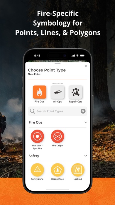
- Build custom incident maps with fire-specific symbology.
- Record tracks, draw lines, drop points, and calculate areas in acres.
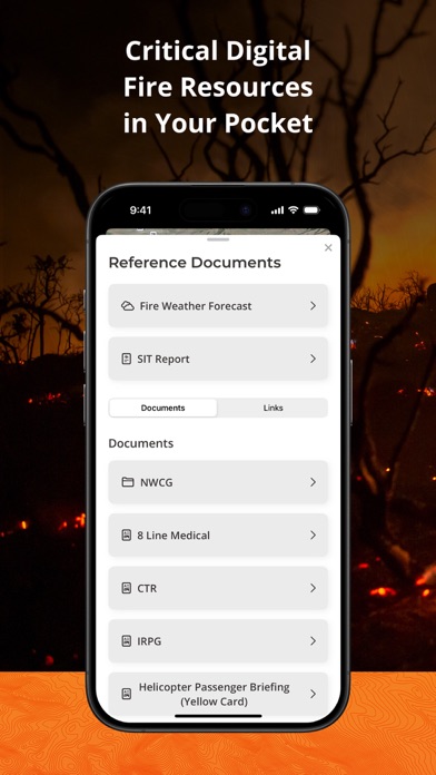
- Access essential reference documents directly in the app.
- Curated map layers designed for wildland fire, including:
- Severe Fire Danger Index
- Fire Weather Advisories
- Ground Medevac Transport Times
- Current Incidents
- Current & Historical Fire Perimeters
- NOAA Weather Radar
- ALERTCalifornia Cameras
- Satellite Heat Detection
- Wind Speed & Direction
- And more!
IGNIS CONNECT: OFFLINE TEAM COLLABORATION
Take fireline coordination to the next level with IGNIS Connect.
Everything in IGNIS Core, plus:
- Team coordination through offline Bluetooth mesh networking. Share points, lines, and polygons—even without cell service.
- A web app for centralized organization management, document and map sharing, and interactive mapping.
- Unified coordination for field crews and office teams, keeping everyone aligned.
Visit http://www.ignistech.io to learn more!
Terms of Use:
https://www.ignistech.io/terms-of-use
Privacy Policy:
https://www.ignistech.io/privacy-policy
Get Help or Leave Feedback:
https://help.ignistech.io/
Or email [email protected]
App information from Apple App Store. IGNIS | Wildfire Operations and related trademarks belong to Ignis Technologies, Inc.