

2 votes - Utilities - First release: 2020-09-28T07:00:00Z
Screenshots


Description - 4+
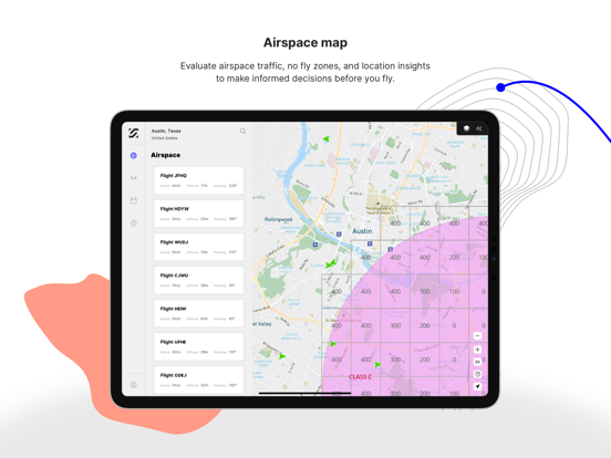
An all-in-one app to manage your entire drone workflow. With SkyGrid Flight Control, exploring airspace is easy, flights are automated, and insights are real time. Our easy to use airspace map includes advanced weather, location, and regulatory insights to make more informed flight decisions. Our drone route planner minimizes manual workflows with automated mission plans and autonomous flight execution. And our AI computer vision allows you to quickly detect objects, such as vehicles, people, and animals, as your drone surveils a defined area.

As a FAA-approved UAS Service Supplier of LAANC, SkyGrid also provides near real-time authorization to fly in U.S. controlled airspace under 400 feet near airports. Part 107 pilots can also submit a further coordination request to fly above the designated altitude ceiling in a UAS Facility Map, up to 400 feet.

How it works:

1) Check airspace & weather: Evaluate airspace, location, and advanced weather insights to see where it’s safe to fly.

2) Plan a flight: Specify your flight parameters to automatically generate area exploration, waypoint, free flight, or multi-objective missions.

3) Get LAANC authorization: If flying in U.S. controlled airspace near airports, request FAA LAANC authorization for auto-approval under 400 feet.

4) Launch or schedule mission: Connect your DJI drone and launch the mission to autonomously perform the predefined flight plan, or schedule flight for a future date.

5) Detect objects: During flight, detect key objects in the real-time video feed with AI computer vision.

Free features: For drone operators to gain access to airspace, plan and execute flights, and detect objects in real time. Download SkyGrid Flight Control to get started.

- Airspace intelligence and advisories

- Advanced weather data

- FAA LAANC authorizations for commercial and recreational flights

- Automated area exploration missions

- Autonomous flight execution

- Flight scheduling

- AI object detection during flight

- DJI mobile SDK support

- Recommended drones: DJI Mavic Air, DJI Mavic 2 Pro, DJI Mavic 2 Enterprise, DJI Phantom 4 Pro V2

Visit www.skygrid.com/flight-control/ to learn more.

About SkyGrid:

SkyGrid is a joint venture between Boeing and SparkCognition. We’re using AI and blockchain to solve the industry’s biggest challenges integrating drones in controlled airspace and executing autonomous operations. We enable a wide variety of commercial drone operations from package delivery to emergency assistance. Learn more about our enterprise solutions at www.skygrid.com/enterprises/.