The app provides a digital location service using N-codes derived from GPS coordinates. It can assist with disaster preparedness and improve efficiency in various industries.
by TORU NISHIOKA★ 0.00 ratingsNavigationFreeData updated 2026-10-28
Record notes with support for .mp3, .m4a, .wav, and .caf formats. Choose 44.1 or 48 kHz sample rates. Enable geotagging for GPS location data. Record in the background and save files automatically. Share audio via email or PC.
Fetch values based on geolocation. Convert to geographical coordinates and vice versa. View location-based data. Save and share coordinate conversions.
Record interactions with GPS coordinates and client details. Capture notes and resources provided. Perform quick assessments and track services. Sync data for real-time updates and client lookups.
The app provides vehicle location checking and history playback. It also allows viewing device alarms and uses cloud storage for faster response speeds.
Optimizes device storage with one click by removing junk files and identifying large media. Deletes duplicate photos and videos. Merges or removes contacts. Analyzes battery usage to improve power efficiency.
Upload photos to identify their precise geographical location using advanced image analysis. Tap to view location details, including map markers and coordinates. Share location data or save it for future reference.
The app records and shares GPS coordinates and field notes. It tracks user movement and provides GPS location services in multiple formats, including MGRS.
Identifies audible stations based on location and terrain. Users can search by location or map, view station listings in list or map format, and check coverage areas.
Provides real-time , atmospheric pressure, latitude, and longitude data. Users can switch between GPS and device altimeter for readings. Camera integration allows photo capture with location data overlay.
Report local issues using GPS to identify locations. Choose from predefined problem categories. Upload photos or videos to support requests. Track the status of submitted reports. Submit requests directly to city officials.
Capture analog signals and view mysterious content
Capture analog TV signals to display mysterious images and videos. Detect magnetic fields to interpret potential communications. Play recorded messages and view live transmissions. Share captured content with others.
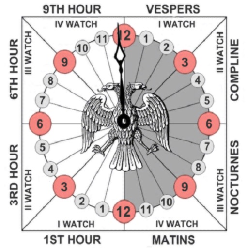
Track prayer times based on time calculations. Adjust for location using GPS or manual input of coordinates. Display times in 12-hour format starting at evening. Include historical context about ancient Judean timekeeping methods.
The app converts between Decimal Degrees and Degrees/Minutes/Seconds notation. It allows viewing converted coordinates in Maps or sending them to GPS Log.
Submit service requests for potholes, graffiti, and street light issues. Select from predefined categories. Upload photos or videos to support requests. Track request status and view submitted history.
Track precise location with Decimal Degrees, DMS, UTM, and MGRS formats. Access topographic maps and route planning. Set waypoints and measure distances. Share coordinates via email or messaging. Sync with GPS devices for real-time navigation.
Track location data without internet connectivity. View date-wise location history on your . Access current location to record movement. No personal data is uploaded or shared. Monitor activity logs directly from the .
Display directions and current location data. View altitude, barometric pressure, and coordinate details. Navigate using coordinates and save location bookmarks. Track sunrise and sunset times. Show solar elevation and azimuth angles.
Study for the CNH exam with topic-based questions and practice tests. Track progress through performance graphs and test history. Customize study plans based on weak areas to improve learning efficiency.