

Apps Like E6B Max: Flight Computer for iPhone and iPad
E6B Max: Flight Computer screenshots
Ranked alternatives
Showing 321–340 of 1,000 ranked alternatives.

The Compass -Simple-
Vida Apps Incorporated
Check direction, customize colors
Check direction using a magnetic . Customize the background and text colors to personal preferences. Adjust settings for optimal visibility.


Converter Pro – Unit Converter
Panoramic Software Inc.
Convert currencies and units instantly
Convert units across 19 categories including acceleration, angle, area, cooking, data storage, density, and energy. Switch between 150+ currencies. Perform calculations for conversions and exchanges. Share results via copy or email.

Ship's Log Book for Captains
Florian Kriesche
Automated logbook for sailors and boaters.
The app automatically creates logbook entries with weather and location data. Users can add pictures, measure heel, and view statistics.


Speedometer Speed MPH Tracker
Rihab Mehboob
Track , record trips, view stats
View data with a display and HUD options. Track trips, record , distance, and duration. Monitor average , top , altitude, and switch between mph and km/h.

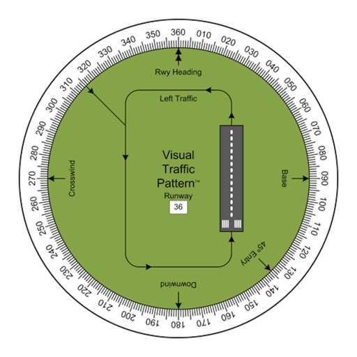
Visual Traffic Pattern
Arthur Varrassi
View runway patterns with finger rotation
Allows pilots to view runway patterns with finger rotation. Display includes left and right patterns, crosswind, downwind, base, and 45-degree entry headings. Magnetic runway orientation matches aircraft heading for approach visualization.

Jeppesen FliteDeck Pro
Jeppesen
Navigate, plan, and execute flights efficiently
Navigate using high fidelity airport maps and enroute displays. Access aeronautical data for flight planning. Streamline operations with integrated electronic flight folders. Monitor fuel efficiency and situational awareness during flights.

Compass Pro - Aircraft
LionsApp di Nallbati Elton
Track position with wind rose and coordinates
Displays wind rose and location details including name, latitude, longitude, and altitude in meters or feet. Saves position data for any global location. Requires location services to detect geographical position.


Nav Camera
Craig Hunter
Record photos and videos with data overlays
Record photos and videos with real-time data overlays. Use augmented reality for navigation. Access proven navigation and image processing technologies. Capture geospatial data during recordings. Share media with embedded location and time stamps.


MuslimPilot Log
MOHAMMED AL OTAIBI
Track prayer times and flight logs
Navigation allows pilots to calculate prayer times adjusted for altitude. Import flight plans to create detailed logs. Track Fajr, Dhuhr, Asr, Maghrib, and Isha times along routes. Sync with flight data for accurate scheduling.

How we rank alternatives
Apps are ranked by functional similarity, category fit, rating confidence, and popularity.