

Apps Like Earth & Sky Explorer for iPhone and iPad
Earth & Sky Explorer screenshots
Ranked alternatives
Showing 541–560 of 1,000 ranked alternatives.

Sky-Map
Rolf Schade
Moving map navigation and flight planning.
The app displays the user's actual position on digital aviation charts. It offers flight planning, route saving, and calculation of distances, flight times, and fuel consumption.
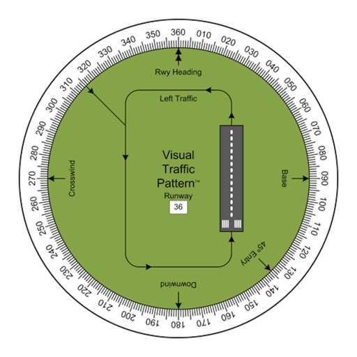
Visual Traffic Pattern
Arthur Varrassi
View runway patterns with finger rotation
Allows pilots to view runway patterns with finger rotation. Display includes left and right patterns, crosswind, downwind, base, and 45-degree entry headings. Magnetic runway orientation matches aircraft heading for approach visualization.


Wind Seeker
Ajnaware Pty Ltd
View local wind and weather conditions.
The app offers a compass view with animated wind vectors, temperature, and humidity. It also includes an augmented reality 3-D view and a searchable map view for global weather station data.

Venus Atlas
Julian James
Explore the hidden surface of Venus.
The app displays a 3D globe of Venus with topography shown in false color. Users can manipulate the globe with gestures, view labels that appear with zoom, and access information about features.

Marker Compass
arakawa yuichiro
Check markers, view phases, add custom points
Display markers on the including the Moon for real-time phase tracking. Add custom markers with Premium mode supporting up to 10 entries. Check accuracy affected by nearby metals or magnets. Navigate using intuitive controls without requiring a map.


Explore Orion
Lockheed Martin corp
Design and mission
The spacecraft's design and mission details. View 3D models of the vehicle. Access information about the Artemis I mission and its objectives. Learn about capabilities for deep space exploration.


Fireballs in the Sky
Curtin University
Report fireballs, contribute to science.
The app allows users to report fireball sightings using augmented reality and sensing technology. Users can recreate their sightings, contributing scientifically useful data to the Desert Fireball Network's research.


altimeter professional
FFZ srl
Track altitude and record position data
Displays altitude using a digital readout and an analog gauge. Tracks maximum height reached during use. Shows altitude accuracy and sensor quality. Utilizes GPS and barometric sensor for precise measurements.



My Сompass Direction Go App
Kujtim Deda
Determine with compass readings
Determine with precise compass readings in degrees and cardinal points. Track real-time orientation as you move. View current coordinates and altitude. Calibrate compass for accuracy.


GPS Camera: Stamp Photo Map
Vijay Bhaliya
Capture photos with GPS coordinates and maps
Capture photos with embedded GPS coordinates and timestamps. View live maps and customize location details including addresses and map types. Edit geotag settings and share tagged images with precise location data.
How we rank alternatives
Apps are ranked by functional similarity, category fit, rating confidence, and popularity.