
UTM Grid Ref Compass
Michael Irving
Locate yourself using UTM coordinates.
The app displays the user's current location in the UTM coordinate system. It provides the UTM Grid Ref, Compass Bearing, WGS84 Latitude and Longitude, and Hemisphere.

Showing 501–520 of 1,000 ranked alternatives.
Michael Irving
Locate yourself using UTM coordinates.
The app displays the user's current location in the UTM coordinate system. It provides the UTM Grid Ref, Compass Bearing, WGS84 Latitude and Longitude, and Hemisphere.

Jason Attard
Track car with GPS
Track parked car using GPS coordinates. View latitude and longitude details. Quickly locate spot while moving. Display precise data without extra features.

MIIN Ltd
Locate location with coordinates
Find latitude and longitude coordinates of your current location in decimal degrees and degrees-minutes-seconds. Tap coordinates to copy to clipboard. Save coordinates with a custom name. Share coordinates via email or messaging.

Cyril Godefroy
Record location, track movement, geotag photos
Records position, distance, and duration during use. It tracks movement and geotags external photos. Users can review tracks on a map, view speed and distance, and export data as GPX files for other software.

Vijay Bhaliya
Capture photos with GPS coordinates and maps
Capture photos with embedded GPS coordinates and timestamps. View live maps and customize location details including addresses and map types. Edit geotag settings and share tagged images with precise location data.


Anthony Dunk
Track routes, record trails, and return safely
View current location in UTM or lat/lon formats. Record and save waypoints. Track movement with up to 40 tracklog points. Navigate using GPS for hiking, mountain biking, and kayaking. Switch between coordinate systems. Store up to 3 waypoints.

Bist LLC
Navigate with voice prompts and route manager
Access vector charts, freshwater maps, and USACE river maps. Create or import routes using GPX/KML. Receive voice prompts for navigation. View tide and current predictions. Rotate charts with text remaining upright.

UMRA TECH LLC
Find direction with compass
Locate direction using GPS and compass. Display map with current location and direction. Use accelerometer to adjust orientation. Show prayer times based on location. Track daily prayer schedule.

Ivan Blajic
Plan routes, view maps, and overlay grids
View maps in multiple styles and overlay grids for precise navigation. Access live location data including coordinates, address, heading, and speed. Plan routes with detailed terrain analysis and save custom waypoints.

RIP CURRENT INTERACTIVE LLC
Pray with unequal hours and track time
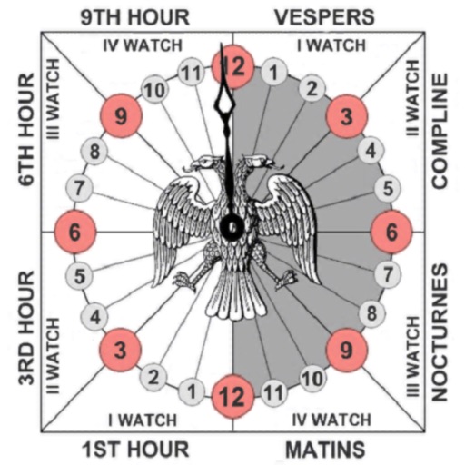
Track prayer times based on time calculations. Adjust for location using GPS or manual input of coordinates. Display times in 12-hour format starting at evening. Include historical context about ancient Judean timekeeping methods.


Mobile Card Games & Travel Apps LLC
Check elevation and track altitude
Monitor elevation with a large, clear display that adjusts to your device. Choose between GPS or barometric sensors. Track real-time elevation changes. View barometric pressure in multiple units. Display accuracy details visually.

Neukadye, LLC.
Determine remote GPS location with bearings.
The app determines a remote GPS location using compass bearings from multiple geolocated points. It supports automated or manual entry of readings and displays results on a map.



MASAO SOTA
Digital meter design with GPS.
The app offers a GPS speedometer, odometer, and trip meter with an 80s digital meter design. It also includes fuel management and a music player, calculating fuel economy and remaining fuel.
Apps are ranked by functional similarity, category fit, rating confidence, and popularity.