Display a compass overlay on the map. Navigate with turn-by-turn directions. Show current speed, altitude, and heading. Indicate device orientation with a level feature.
by 著显 朱★ 5.01 ratingsNavigationFreeData updated 2026-09-08
Calculate pressure and density altitudes, true airspeed, and mach number. Determine wind correction angle and true heading. Compute crosswind, headwind, and tailwind. Find ground speed and flight time. Calculate fuel burn and cloud base.
A displays cardinal directions and uses GPS to determine location. It features a realistic virtual interface, shows geographical directions, and helps users navigate effectively.
The app offers a compass view with animated wind vectors, temperature, and humidity. It also includes an augmented reality 3-D view and a searchable map view for global weather station data.
Provides navigation with detailed vector maps that support zooming at any level. Locate points of interest, plan routes, and save data to avoid roaming charges. Includes continuous map updates without requiring an internet connection.
Navigate using distance and direction without a map. Set destinations and receive step-by-step guidance. Track progress and view distance metrics. Works independently on Apple Watch with GPS.
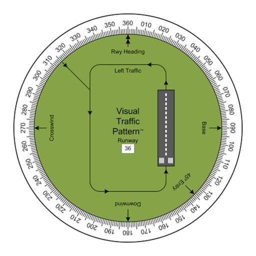
Allows pilots to view runway patterns with finger rotation. Display includes left and right patterns, crosswind, downwind, base, and 45-degree entry headings. Magnetic runway orientation matches aircraft heading for approach visualization.
Navigate locations with turn-by-turn directions and map views. Search for points of interest and save favorite spots. Share routes with others and receive real-time location updates. Track progress and explore nearby landmarks.
Navigate offline with turn-by-turn directions and traffic updates. Save and share routes. Rate locations and mark favorites. Plan trips with user-generated content. Track progress and explore new places.
Map with detailed vector navigation. Zoom at any level. No internet required. Avoid roaming charges. Locate nearby points of interest. Save data usage. Sync with real-time updates from OpenStreetMap.
Track location with live coordinates and altitude. Convert GPS data to readable addresses. Monitor speed and heading for motion tracking. Access real-time environmental data for navigation.