

Apps Like Compass XL for iPhone and iPad
Adds a compass to the iPad.
The app adds a compass to the iPad, utilizing the built-in magnetic compass or a sun compass. It is suitable for outdoor activities like hiking and biking.
Compass XL screenshots
Ranked alternatives
Showing 201–220 of 1,000 ranked alternatives.

Compass XXL
ExaMobile S.A.
Rotate , find direction, navigate trails
Use to determine directions and navigate. Rotate device 360 degrees for orienteering. Access camera preview to align with surroundings. Set bearings and track movement without GPS.


HUD Widgets
HUDWAY LLC.
Track speed, distance, and weather
Display speedometer in digital or HUD mode with compass, odometer, and distance traveled. Show trip information including driving score based on acceleration. Track eco-driving metrics and weather data.

OutDoors GPS France - IGN Maps
RoadTour LLC
Find routes, track your path, download
View topographic, satellite, and road . Download official IGN for offline use. Find and follow hiking and biking routes across Europe. Record, save, and share routes online. Set waypoints and track progress. Navigate without cellular signal.


Sun n Moon for iPad
David Gibson
Sun and moon times anywhere.
The app calculates sunrise, sunset, moonrise, and moonset times for any location. It includes a moonphase calendar, animation, and a compass showing sun and moon positions.





Best Taxi Meter
Muhammad Saeed
Customize, track, and charge rides
Track trips with real-time maps and directions. Customize settings for accurate metering. Record and export trip history with sorting options. Charge passengers for rides and manage multiple trips.

UTM Grid Ref Compass
Michael Irving
Locate yourself using UTM coordinates.
The app displays the user's current location in the UTM coordinate system. It provides the UTM Grid Ref, Compass Bearing, WGS84 Latitude and Longitude, and Hemisphere.

GPS Map Camera Geotag Location
Nikhil Viradiya
Tagline
Photos with GPS data including , time, weather, and compass. Share geotagged photos with contacts. Add map markers, latitude, longitude, and altitude to images. Stamp photos with date and time. Sync data with captured photos.
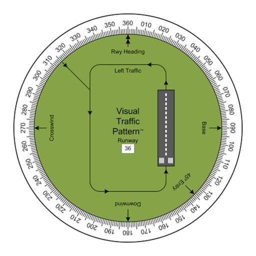
Visual Traffic Pattern
Arthur Varrassi
View runway patterns with finger rotation
Allows pilots to view runway patterns with finger rotation. Display includes left and right patterns, crosswind, downwind, base, and 45-degree entry headings. Magnetic runway orientation matches aircraft heading for approach visualization.

How we rank alternatives
Apps are ranked by functional similarity, category fit, rating confidence, and popularity.