Calculate wind components, temperatures, altitudes, and airspeeds. Input runway number, wind direction, and speed. Determine headwind, tailwind, and crosswind values. Adjust for parallel runways based on magnetic heading.
by Leonard Robinson★ 4.644 ratingsUtilities$2.99Data updated 2026-09-08
Calculate , headwind, and tailwind components for takeoff and landing. Adjust wind speed and direction with drag and pinch gestures. Receive warnings when user-defined wind limits are exceeded.
The app calculates crosswind, headwind, and tailwind based on runway and wind selection. It provides Canadian Runway Friction Index (CRFI) for safe landings and includes a runway length utility.
Calculate pressure and density altitudes, true airspeed, and mach number. Determine wind correction angle and true heading. Compute crosswind, headwind, and tailwind. Find ground speed and flight time. Calculate fuel burn and cloud base.
Track wind conditions with detailed forecasts, maps, and compass readings. Monitor wind speed, direction, and gusts. Receive push notifications for wind alerts and storm warnings.
Calculate -related conversions, fuel consumption, and navigation metrics. Perform arithmetic operations and unit conversions. Track time, distance, and speed. Sync with Apple Watch for real-time updates.
The app collects detailed weather information including wind speed, direction, temperature, and humidity. Users can share these reports instantly through various platforms and online weather services.
FlightWinds calculates crosswind, tailwind, and headwind components for takeoff and landing. Displays dual runway views. Alerts users when wind limits are exceeded. Offers an intuitive interface and universal access.
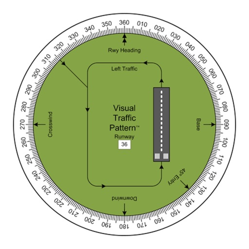
Allows pilots to view runway patterns with finger rotation. Display includes left and right patterns, crosswind, downwind, base, and 45-degree entry headings. Magnetic runway orientation matches aircraft heading for approach visualization.
Calculate groundspeed, true heading, compass heading, leg time, distance, fuel required, fuel flow, and endurance for flight planning. Convert airspeed, altitude, and temperature.
Displays current wind direction and speed, runway course, and cross, head, or tailwind components. It shows applied wind limits, forbidden wind angles, and a maximum wind speed table. Users can set up wind parameters for accurate flight evaluations.
View satellite imagery updated in near real-time. Track hurricanes, storms, and severe . Monitor wildfires and smoke. Explore current and forecasts for rain, wind, temperature, and pressure. and interact with global maps.
Navigation provides flight planning and in-flight calculations. Users can customize quick access buttons, configure units, and manage blocks and airtime.
Control thermostat settings remotely, adjust temperature schedules, and monitor energy usage. View system status, receive alerts, and integrate with smart home devices for automated temperature management.