Monitor takeoff performance by comparing actual data to planned values. Input runway takeoff distance available, takeoff roll, and stopping distance. View real-time feedback on aircraft performance during takeoff events.
by Raymond Chase★ 5.02 ratingsNavigationFreeData updated 2026-09-06
Plan flights with route mapping, fuel calculations, and weather data. Track aircraft in real time. Access offline maps and charts. Set flight parameters and monitor navigation. Share flight data with other .
Monitor earthquakes with real-time updates and GPS compass maps. Display professional data including altitude, orientation, air pressure, and coordinates. View environmental metrics like humidity and temperature.
The app provides data-driven debriefs for pilots, analyzing flights into segments to evaluate performance. It offers maneuver scoring, reviews of flight data, and chart overlays to identify areas for improvement.
Track trailer locations in real-time using GPS. View distance and status updates on a map. Receive cargo condition reports to confirm readiness for pickup.
Monitor fleet vehicles in real time with location and movement data. View daily distance, driving times, stops, fuel levels, and driving behavior scores. Search vehicles by name, plate, or driver and apply filters.
The app reproduces a massive 3D battle to check device power. Users can manage individual units or view the battle from above, similar to strategy games.
Make decisions using interactive tools like random selection, spin arrows, fortune wheels, and rock-paper-scissors. Flip coins, generate random numbers, roll dice, and use a full-screen timer. Play with another device or alone.
Track flights by logging and improving them using Vario with sensor fusion and sound alerts. Monitor ground speed, altitude, wind speed, and direction. View live maps and fly with friends. Sync with Apple Watch.
Track and distance with real-time GPS. Log trips and view detailed statistics. Use drag meter for performance analysis. Monitor odometer and fuel efficiency. Access advanced HUD display for driving insights.
View nautical charts in S-57, S-63, iENC, and BSB/KAP formats. Use external NMEA/AIS data over WiFi. Display official HO S-57/S-6 charts. Navigate river, channel, and harbor routes. Access real-time positioning and vessel tracking data.
Calculate distance, time, and fuel consumption using parameters like Mach number, TAS, ISA deviation, and wind components. Create and manage aircraft profiles with customizable fuel usage based on distance flown.
Plan flights with route management tools that include data, NOTAMs, and TFRs. File flight plans and access ASA's 2024 FAR/AIM for regulatory compliance. View high-quality charts and briefing materials for pre-flight preparation.
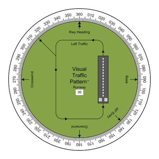
Allows pilots to view runway patterns with finger rotation. Display includes left and right patterns, crosswind, downwind, base, and 45-degree entry headings. Magnetic runway orientation matches aircraft heading for approach visualization.
Track skiing performance with speed, altitude, slope, and distance data. Create and organize trips to store runs and view trip statistics. Access photos taken during the session. Customize screen layouts to focus on relevant data.
Tracks location, speed, altitude, heading, acceleration, g-force, and atmospheric pressure. Displays and records current weather. Plays back tracks at multiple speeds. Provides suggested routes for reference. Allows pausing and resuming tracking.
Monitor and control vehicle locations in real time. Track fleet movements, set geofences, and receive alerts. Manage assets like cars, cargo, ships, and aircraft.
The app computes rolling block/flight time requirements for single or dual piloted operators. It also assists with departure gradients, climb performance, approach planning, landing performance summaries, and aviation conversions.