Back-Track
Pilot X Ltd
Navigate back to saved locations easily.
The app uses device GPS to guide users back to saved locations. Users can mark their current position or enter coordinates to save a destination.

Showing 321–340 of 1,000 ranked alternatives.
Pilot X Ltd
Navigate back to saved locations easily.
The app uses device GPS to guide users back to saved locations. Users can mark their current position or enter coordinates to save a destination.

motobit GmbH
Plan routes, track tours, and navigate safely
Plan routes using four methods: fast with highway, fast without highway, winding, and sport/touring. Navigate with turn-by-turn GPS via audio or display. Track tours and join a community of riders. Share routes and view real-time traffic updates.

Fire Front Solutions Pty Ltd
Generate incident maps quickly offline.
The app allows for the creation and export of incident maps. It supports multiple export formats including GPX, KML, CSV, and JPG.

RIP CURRENT INTERACTIVE LLC
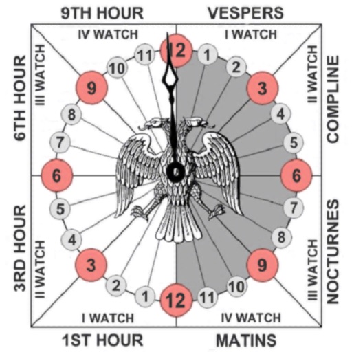
Pray with unequal hours and track time
Track prayer times based on time calculations. Adjust for location using GPS or manual input of coordinates. Display times in 12-hour format starting at evening. Include historical context about ancient Judean timekeeping methods.

锦滔 欧
Measure and track location
Provides real-time , atmospheric pressure, latitude, and longitude data. Users can switch between GPS and device altimeter for readings. Camera integration allows photo capture with location data overlay.
Georgios Graikousis
Measure surface area and convert coordinates.
The app converts coordinates to UTM EGSA87 Datum and calculates polygon area in square meters. It sends measurements via email in DXF, KML, or TXT file formats for use in various applications.

Chris Cornelis
Tag your photos with location data
Adds location tags to photos taken with supported devices. Users can geotag images from iPhone, iPad, Mac, Dropbox, and Flickr. The automatically records location data during photo capture. Tags help organize and identify where photos were taken.


Thirty Seven Inc.
Track altitude and air pressure changes.
The app provides live readings for pressure, altitude, and rate of change. Users can record sessions, review history, and export data as CSV.


怡 左
Track behavior and analyze stats
Track behavior using GPS and smart algorithms. Record speed, acceleration, and braking patterns. Generate detailed statistics and visual analysis. Set safety goals and monitor progress over time. Share reports with others for feedback.


Calculated Industries, Inc.
Calculate and convert units on the go
Perform calculations and unit conversions for aviation tasks. Access over 100 calculators with equations and graphics. Save and retrieve calculation results. Convert units for fuel, distance, speed, and weight.

Lars Hansen
Save map positions with notes.
The app saves up to 50 map positions with notes. It displays the current address for the user's location and retrieves saved positions using latitude and longitude.
Bhavik Savaliya
Find direction
Find direction using location and . Display accurate heading. Show prayer times based on location. Include Kaaba location details. Allow users to set prayer reminders. Share direction via social media.
Apps are ranked by functional similarity, category fit, rating confidence, and popularity.