

Apps Like Mobile Traffic for iPhone and iPad
Track and view real-time maps
Provide real-time updates for and Baldwin Counties. View interactive maps with current conditions. Navigate using turn-by-turn directions. Receive alerts for accidents or road closures. Share location with others for real-time tracking.
Mobile Traffic screenshots
Ranked alternatives
Showing 641–660 of 1,000 ranked alternatives.

3D实况卫星导航-指南针北斗智能语音导航
Hubei Kanju Technology Co., Ltd.
Navigate with 3D satellite views
Navigate with live 3D satellite maps and voice guidance. View detailed road and building models. Access fishing and travel exploration tools. Use practical navigation features for precise route planning and real-time updates.

Lucca Travel Guide with Offline City Street Map
eTips LTD
Navigate AR and maps
Navigate using augmented reality for location-based directions. View zoomable maps detailed regional coverage. Explore interactive points of interest including public transport, restaurants, and attractions.

KGM Türkiye Trafik
KARAYOLLARI GENEL MUDURLUGU
Navigate with real-time route updates
Plan routes between highways, state, and provincial roads. Display directions with closed road alerts. View total distance and travel time. Access real-time traffic information. Receive road condition updates along the route.

Naples Tour Lite
Raffaele Di Marzo
Explore ' history and culture
Navigate with turn-by-turn directions to attractions like museums, churches, and monuments. View detailed location information and access visitor tips. Save favorite spots and plan routes efficiently.

Gipsyy: Travel in Europe
GOGIPSY - TECNOLOGIA, UNIPESSOAL, LDA
Explore routes and track your journey
Navigate routes with turn-by-turn directions and real-time traffic updates. Find nearby points of interest and plan stops. Access offline maps and track vehicle location. Share trip details with others. Adjust settings for different modes.

Live Transit
Squideye, Inc.
Track buses, view routes, explore stops
Track buses in real time with updates on a map. Tap buses to view their routes and current locations. Access detailed route information and schedules. Plan trips using the city's public transportation network.
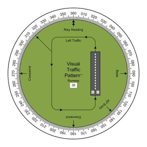
Visual Traffic Pattern
Arthur Varrassi
View runway patterns with finger rotation
Allows pilots to view runway patterns with finger rotation. Display includes left and right patterns, crosswind, downwind, base, and 45-degree entry headings. Magnetic runway orientation matches aircraft heading for approach visualization.

EV Car Charging Stations App
Aleksandr Alekseev
Find and view details
Find nearby using an interactive map. Search by location or address. Filter by type, availability, and price. Sort results by distance, rating, or price. View real-time updates on station status and availability.

Resser Spot
Industrias Resser sa de cv
Track vehicle location in real time
Track vehicle location in real time with notifications. Share temporary links to guide others to your car. Access driving documents like license and registration securely.

Winnipeg Transit
City of Winnipeg
Plan trips, track buses, view maps
Plan trips from origin to destination using Navigo. View real-time stop schedules and route maps with destination-specific paths. Track trips in real-time with On the Go. Find route maps and schedule information.

RijekaBus
Walletap d.o.o.
Track buses and view real-time schedules
View real-time bus schedules, routes, and arrival times. Locate nearest stations and check current timetables. Track individual buses on an interactive map. Receive live updates on bus movements and stop arrivals.

Flit for Weed
Justin Cegnar
Find dispensaries and track routes
Find nearby dispensaries with real-time location updates and accurate data. Display routes and travel times based on driving or walking mode. Automatically detect movement type and update nearby locations as you move.

Where2Go: GPS Photo Compass
Pavel Vorontsov
Navigate with GPS and saved points
Navigate using a GPS to any saved location. Save current position, input coordinates manually, or extract GPS from photos. View saved points history and export coordinates to Google or Apple Maps.

Globe 3D Earth: World Map Live
Shams Alam
Explore 3D maps and locations
View a 3D with GPS tracking and real-time compass. Explore locations with media features and video streams. Rotate, zoom, and navigate the Earth. Access location-based content and track movement.

SmartWheels GPS
SmartWheels GPS, Inc
Track vehicles, view insights, manage accounts
Track vehicles in real time with maps and location updates. Receive driving insights like speed and route history. Manage multiple vehicles from one dashboard. Set alerts for geofences and unauthorized activity.

Tracking for iPad
Ndili Technologies, Inc
Track location in real time
Allow contacts to view real-time location and location history with timestamps and speed data. Share current position and past movements. Attach photos, videos, and notes to location trails. Sync across iPhone and devices.

LiA app
CITYWAY
Find stops, track real-time schedules
Locate nearby bus and tram stops, bike parking, relay parking, and nearby points of sale. View real-time schedules for upcoming bus and tram arrivals. Find optimal routes combining walking, cycling, bus, tram, funicular, or LER.

London Underground Planner
Chumak Oksana
Plan your route and track station updates
Navigate ’s Tube network with smart route planning to find the fastest path. Access official maps for accurate navigation. View detailed step-by-step directions and switch between lines. Check live service status for delays or closures.
How we rank alternatives
Apps are ranked by functional similarity, category fit, rating confidence, and popularity.