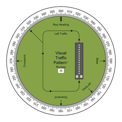
Allows pilots to view runway patterns with finger rotation. Display includes left and right patterns, crosswind, downwind, base, and 45-degree entry headings. Magnetic runway orientation matches aircraft heading for approach visualization.
Plan flights with detailed weather data, airport information, and NOTAMs. Overlay georeferenced charts on aviation maps. Access IFR and VFR plates for over 200 countries. Manage and download airport plates in advance.
Plan flights with route mapping, fuel calculations, and weather data. Track aircraft in real time. Access offline maps and charts. Set flight parameters and monitor navigation. Share flight data with other .
Plan flights with route management tools that include data, NOTAMs, and TFRs. File flight plans and access ASA's 2024 FAR/AIM for regulatory compliance. View high-quality charts and briefing materials for pre-flight preparation.
Ask questions, take tests, train ATC communication
Ask questions and receive expert-style instruction using AI. Practice FAA exams, improve ATC communication, and access aviation study materials. Track progress and review theory resources for pilot licensing preparation.
Plan non-revenue travel by searching for flights and viewing seat availability estimates. Track flight status and receive updates on boarding. Manage travel dates and preferences for standby trips.
Perform aeronautical calculations including wind correction, fuel planning, and time-speed-distance. Input data to compute required values. Access multiple calculation modes and reference charts. Save and review calculation history.
Sheet Metal allows users to generate patterns for cones and other complex shapes. Input dimensions and material properties to calculate angles and layout dimensions. Export results for fabrication use.
Plan and navigate using an interactive moving map with aeronautical charts, satellite, or vector map backgrounds. View real-time flight data, track position, and adjust routes. Access up-to-date weather and airspace information.
Track time and night hours for airline, student, and private pilots. Log IFR, VFR, and night flights in compliance with EASA and FAA regulations. Import history from previous logbooks. Store logs in FAA and EASA approved formats.
Navigate using GPS, AIS Online, and radar. View charts for coastal boating, sailing, and fishing. Track tides and currents. Set anchoring points. Sync with Apple Health. Share routes and waypoints.