Display markers on the including the Moon for real-time phase tracking. Add custom markers with Premium mode supporting up to 10 entries. Check accuracy affected by nearby metals or magnets. Navigate using intuitive controls without requiring a map.
View tour details, including daily itineraries, hotel information, and transfer arrangements. Access destination-specific knowledge and local insights. Receive real-time updates and navigate with integrated maps.
Use the built-in LED for bright lighting and emergency SOS signals. Access a compass with true and magnetic north options. View a map with custom pins. Measure distances with an adjustable ruler in inches and centimeters.
The app provides over 70,000 topographical maps from Natural Resources Canada and USGS. Users can view maps and search for over a million features without a network connection after downloading.
Determine UTM references, hemisphere, and WGS84 coordinates. Display device accuracy readings. Share location via Twitter. Includes USA UTM zone guide.
View current location in UTM or lat/lon formats. Record and save waypoints. Track movement with up to 40 tracklog points. Navigate using GPS for hiking, mountain biking, and kayaking. Switch between coordinate systems. Store up to 3 waypoints.
View real-time camera and map views with markers and up to 8x zoom. Adjust orientation for navigation. Track bearings for land, sea, or air travel. Sync with devices for accurate directional guidance.
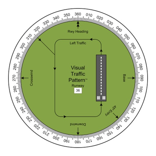
Allows pilots to view runway patterns with finger rotation. Display includes left and right patterns, crosswind, downwind, base, and 45-degree entry headings. Magnetic runway orientation matches aircraft heading for approach visualization.
Navigate waterways with detailed charts, build routes, and record tracks. View tides and currents. Set waypoints and track progress. Share maps and access free US charts for safe boating.
APPAS SOLUTIONS, SOCIETATEA CU RASPUNDERE LIMITATA
Capture in 45x view
Take photos with 45x digital . Pinch to in or out. Manually focus and capture zoomed images. Access a secret folder for secure storage. Use compass to determine cardinal directions. View GPS coordinates from GLONASS system.
The app determines the qibla direction from any location and calculates prayer times for the user's city. It provides prayer time notifications with customizable Adhan for each prayer.
Navigate using and compass to locate targets. View a smart arrow indicating direction to the target. Display speed, altitude, and distance to the target. Includes a built-in compass for orientation.
Track location, altitude, and direction with real-time map updates. View geographic coordinates, address, and atmospheric pressure. Use a detailed compass for navigation. Share photos with altitude, coordinates, and address data.