View speed cameras and checks, including fixed, average, red light, trailer, and mobile types. Check bus, train, and tram departures. Find parking availability and electric car charging stations. View accidents, hazards, and roadworks.
by Pit Schneider★ 5.07 ratingsUtilitiesFreeData updated 2026-09-10
Navigates users through facilities with step-by-step directions. Guides to optimal parking areas and entrances. Provides turn-by-turn navigation to appointments and back to parking. Helps reduce time spent moving within the .
Locate position in Wismar Bay and Bay of Greifswald. Display sensitive areas and boating rules within Natura 2000 zones. Show real-time status of protected area boundaries.
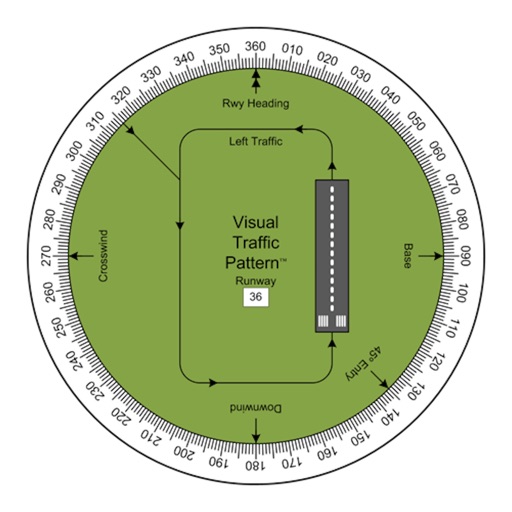
Allows pilots to view runway patterns with finger rotation. Display includes left and right patterns, crosswind, downwind, base, and 45-degree entry headings. Magnetic runway orientation matches aircraft heading for approach visualization.
Search stations and stops by transport mode and line. View departures in both directions. Track live arrivals with real-time updates and delay information. See stations served by each RER. Navigate with a clear and intuitive interface.
The app provides an overview of public and regional holidays, school vacations, and synchronized personal calendars. Users can view important events at a glance and create new calendar entries quickly.
Provide real-time GPS navigation with turn-by-turn voice guidance and live traffic updates. Display speed limits and alert drivers to traps. Access offline maps for areas without internet. Share routes and track progress during trips.